Since the drone incidents at Gatwick and Heathrow Airports in 2018 and the public concerns relating to terrorism privacy and security the perception of drones has hit rock bottom as is reported in the PwC research paper Building Trust in Drones. Concurrently, however, there are numerous predictions for the growth and value of the industry, and the benefits drone use brings to the economy and society.
Public buy-in is therefore going to be essential if the industry is to fulfil this potential. Usage, if not public image, is certainly on the rise: in mid-2014 there were 359 people in the UK permitted to operate drones of up to 20kg. As of February 2020 there were around 5,750 permitted operators in UK airspace.
Drone variation
- fixed-wing
- rotor
- multi-rotor
- hybrid, akin to a helicopter with wings.
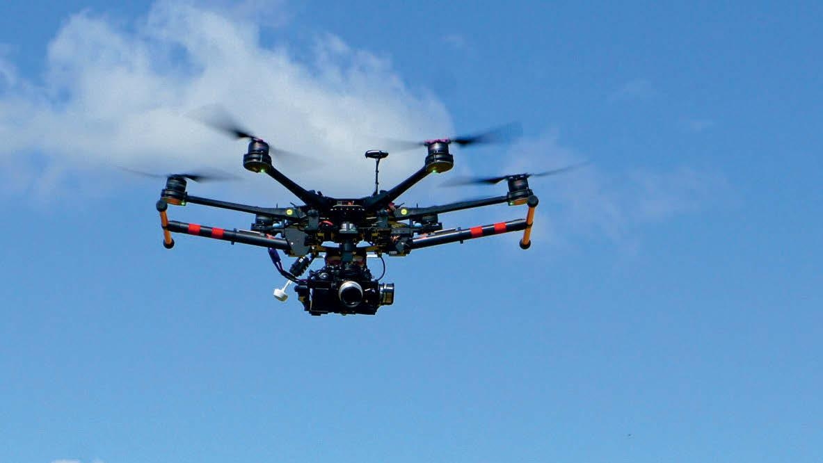
Multi-rotor drones can hold their position in the air, assuming they have an on-board global navigation satellite system (GNSS) as most now do. This makes them particularly useful and safe in confined areas, those that require controlled use, such as towns and cities, or when inspecting infrastructure, such as buildings or bridges.
The typical drone is battery-powered and manoeuvred by propellers. Flights are limited in range and time by the battery life, payload, line of sight and regulatory constraints, and depend on radio signal from the controller. Drones now come with specifications and features previously only available on high-end and expensive vehicles, such as avoidance sensors, gimbals – a pivoted support that allows the rotation of an object about a single axis – and microprocessors, which are used for holding a camera or sensor and stabilisation.
"Drones now come with specifications and features previously only available on high-end vehicles"
As a drone's flying capability and ability to carry a heavy payload reliably are key, manufacturers are reducing sensors to a suitable weight.
- are small, flexible and easy to handle compared to more traditional equipment
- are comparatively low in cost
- produce no direct emissions
- provide information in close to real time, offering a better understanding of the environment and dynamics offer improved safety
- reduce survey time, improving site or asset management
- enable operators to work around difficult weather, such as clouds, that usually limit other remote-sensing platforms.
Increased research is accompanied by the growing standardisation of product, manufacturing operations and procedures, data processing and analytical software.
As time progresses, and with the standardisation of drone technology such as flight planning and geo-fencing – a software feature that uses GNSS to define boundaries – along with the continued evolution of regulations, drone use will become more widespread and efficient.
Standardisations will result in reliability, while analysis methodologies will see the more risk-averse user adopt drone technologies into their existing workflows.
Significant growth of the industry is already under way and the commercial use of drones is gaining momentum as many domains now see them as another important tool – with the added benefits of decreased cost and increased reliability. As the hardware integrates with new software, uptake by individual operators and large organisations will increase further.
Industry regulation
Regulations are currently being developed to meet the UK's Civil Aviation Authority (CAA) aim of enabling the safe integration of all drone operations into the UK's airspace. As of 30 November 2019 it has been illegal to fly a drone in the UK without registering with the CAA and passing a theory test. If you want to fly a drone for commercial reasons, you'll also need to get permission from the CAA.
- a person must not act recklessly or negligently, in a manner likely to endanger an aircraft or any person in an aircraft
- a person must not cause or permit an aircraft to endanger person or property.
Using a drone in your business
Using drones can mean improvements at every point of the project triangle: cost, time and quality. The use of drones on construction sites has increased as the benefits of drones – and the data they can derive – are realised.
Drone data can, for instance, be used to produce accurate topographical and 3D maps that are potentially suitable for input into building information modelling (BIM) or other systems to allow for data analysis.
Many companies report that using drones for mapping can reduce the time required on site by 25 per cent compared to more traditional survey methods. Surveying by drones can also produce far richer data and avoids surveyors having to walk around a busy construction site.
Drones with optical sensors can provide a useful snapshot in time to monitor construction works and help to verify work carried out by subcontractors. This helps with both time management and dealing with risks, such as health and safety, and any unforeseen project issues. Drone imagery also offers an opportunity for communicating with clients and showing progress effectively.
- check the type and quality of the sensor
- find out the level of maintenance that will be necessary
- ascertain how many motors you require and how long they will last
- check the battery shelf life; find out the cost of replacing batteries
- check the drone's safety features; does it have GNSS and a return-to-home function; is geo-fencing provided?
- check the maximum wind speed in which the drone can operate
- ensure there is a warranty.
You should also bear in mind that if you are planning to fly drones in rural areas of the UK, you will need to complete the required ground school training and obtain a permission for commercial operations from the CAA. Further qualifications may be required for use in urban areas. You must then maintain a certain level of pilot competency by flying regularly – at least two hours every three months – and ensure you have the commercial business pipeline to maintain this regular usage.
Data is, of course, another key consideration. You may start producing large data sets that require additional digital storage hardware, or if using software or storage that is based on the cloud, you will need access to a high-speed internet connection. Cyber security is an issue to be aware of, especially if there is involvement with critical infrastructure such as nuclear power plants or military sites, or other sensitive projects. To achieve more advanced results, such as producing 3D data, you may need to gain a further qualification or training and purchase additional processing software.
You will also need to ascertain how many employees will be flying the drone.
Depending on your business, several qualified pilots may be required to fly the craft, or it may make more sense to train just one person if you are not likely to be using it regularly. Another option could be to use external contractors, or else a hybrid business model where the more straightforward drone requirements are carried out in house and external experts are used for more advanced requirements.
Finally, you should consider costs and risks. If you plan to use a drone for a relatively simple purpose with a tried and tested product and data collection methodology, then the drone itself will be fairly straightforward and affordable with an outright cost of around £1,500–£2,000.
There are also, however, the hidden costs of drone use to acknowledge, such as insurance, additional computer hardware for data storage and processing, and ongoing maintenance and time inputs.
As with all other aspects of a project, drone risks should be managed responsibly, so make sure you ask yourself at the outset 'How do I minimise the risk to my business and manage liability before something goes wrong?'
The future
Links between the different parties, manufacturers, practitioners, regulators, governments and standards bodies, among others, have grown stronger in recent years, and can serve as the foundations for the growth of a safe, secure and fully accountable drone industry.
Drones and associated workflows will eventually come as a complete package, as some do already, ensuring compliance with standards in manufacturing, pilot competency, safety and regulation, as well as approved methodologies for automated data collection and analysis.
Ongoing developments in regulation will ultimately ensure safety security and accountability. Advances in artificial intelligence and machine learning will allow automated approaches to analysing gigabytes of image data. This will be particularly useful in the infrastructure inspection market.
As the dots are joined over the coming years, drones are likely to be used for everyday tasks such as fertilising crops, monitoring traffic in urban areas, delivering packages to remote rural regions, or carrying out express deliveries in urban areas and emergency deliveries of medical packages, such as defibrillators or blood.
In the UK, NHS Highland is working with Highlands and Islands Enterprise and the University of the Highlands and Islands on a project that could see drones pick up and deliver items across its regions. In some areas, drones may be faster than current transport methods, and there is the added advantage of reduced carbon dioxide emissions in cities. Research is currently being carried out into using drones to take water samples from lakes and rivers and air samples from volcanoes, or to carry passengers, and into the development of drones with nozzles for 3D printing, among other potential uses.
"Drones and their associated workflows will eventually come as a complete package ensuring compliance with standards"
If drones are to be integrated into society, though, we need to ensure their safety, reliability and accountability. The necessary systems are developing apace as technologies improve and regulation is being strengthened.
Peter Kinghan MRICS is technical director at SLR Consulting pkinghan@slrconsulting.com