Geospatial data technologies are becoming more powerful, more effective, and more accessible. As we have seen over the past 20 years of the internet, new technological capabilities present new risks and potential harms as well as benefits. Many developments can disrupt balances of power in markets, and in relationships between different groups in society.
Geospatial data technologies are now coming to be seen as one of the current wave of digital developments, sometimes called the fourth industrial revolution, alongside the internet of things and emerging applications grouped loosely together as artificial intelligence (AI). To date, though, geospatial technologies have not featured very much in discussion around data ethics that accompanies development and adoption of those other advances.
This needs to change. Given current concerns about how internet user data is used, we can no longer assume that other complex data applications can be deployed at large scale by many organisations, simultaneously, directing numerous often automated decisions, without any risk of harm. Advances in geospatial data applications bring new capabilities and new powers – and, to paraphrase the Peter Parker principle – with power should come responsibility.
This is not to try to halt progress and lose the many benefits that new geospatial applications offer, but to recognise that such applications present new risks. These risks can be managed successfully to minimise harm and maximise benefits, but only when they are first recognised and explored.
Lack of guidance
Currently, users of location data have no common guidance or frameworks for understanding where their actions could cause harm or create risks, or how to mitigate these. The need for such guidance grows as more geospatial data applications are made available to non-specialists – such as restaurants turning to local delivery services as add-ons to existing data-driven services.
For the past year, the Benchmark Initiative in the UK and EthicalGeo in the USA have explored risks and challenges around increasing use of location data, and promoted understanding of possible solutions.
- improve standards of practice
- help to protect users of data and individuals who could be affected
- help to protect the public interest
- harness the benefits of geospatial technologies.
Risk awareness on the rise
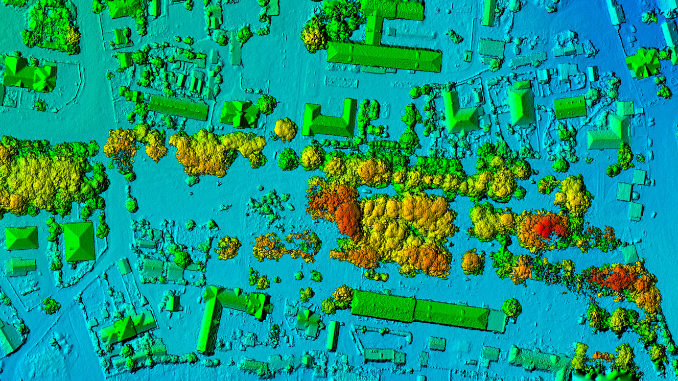
Data about places and the people in them is being put to an ever-growing number of uses. One person is often the user of a mobile map and at the same time the object of tracking in digital mapping by organisations of which they are unaware.
There can be many purposes and potential costs and benefits in play, multiplying at city, national and international scales. The way that costs and benefits from mass, varied use of location data are shared is a new dimension of power relations, adding to and sometimes exacerbating existing imbalances of power.
The public, the media, governments and professionals in many fields are all becoming more aware of these risks. The practice of data ethics is therefore growing, with the aim of ensuring responsible and sustainable use of data in the interests of individuals and society.
- undue manipulation
- discrimination
- opacity
- undermining personal privacy.
Exploration of data ethics is probably most advanced and – at present – most urgent in relation to online activities, including influencing. In some areas such as health data, common principles are relatively mature and developed, while in others, such as AI there is a lot of activity, but a consensus has yet to develop.
- domains such as rights relating to data and its use
- sectors such as telecommunications
- professions such as data science
- categories or descriptions of data such as personal data or location.
In this context of greater demand for practical ethical guidance, users of location data should also have tools and terms to explore the potential harms of their activity, to manage the risks, justify their methods, and explain how they make decisions.
"Users of location data should have tools and terms to explore the potential harms of their activity, to manage the risks, justify their methods, and explain how they make decisions"
Ethical questions about geography and geospatial activities have been raised in the past. However, the complexity and range of location data applications now in use has created risks and opportunities that are of a different kind and scale.
We can learn from data ethics development in other fields, and ensure that specific issues relating to location data are in future properly considered as part of the wider data ethics landscape.
Location data ethics in practice
The Locus Charter initiative has been developed by Benchmark and supported by Ordnance Survey and Omidyar Network in dialogue with an international group of geospatial professionals, to stimulate discussion and debate, and to identify common principles.
People working with geospatial technologies should recognise their potential impacts, and should promote good data ethics and practice in their fields. Our work at Benchmark suggests that proper attention to ethics will be essential to realising the full range of benefits these technologies offer, and to increasing recognition of geospatial applications alongside AI, IoT and the current wave of enabling digital technologies.
Common understanding of risks and potential solutions will help geospatial data professionals make better-informed decisions. It also means that the wider public – who are in many different ways the subjects of location data applications – will benefit from common terms and principles for interrogating how that data is used and, where necessary, for holding data users to account.
Geospatial data professionals are like those in other data sectors committed to making applications work better, but many will have had relatively little training in data ethics to navigate the complex and data-rich environments they work in today. The potential impacts of data usage have changed enormously since greater volumes of more granular data have become available. Our experience at Benchmark has been that these professionals will value guidelines that help them to understand and manage risks such as bias in data, and unintended intrusions into personal privacy.
Emerging principles
Much work on responsible use of location data is already in progress. Google’s geospatial technologist Ed Parsons recently described the development of technologies that collect data on how and when people use places while simultaneously protecting their privacy.
The Real Estate Data Foundation has meanwhile developed ethical principles, and cities are exploring how to govern their increasing use of applications based on local data.
Practical guidelines have to acknowledge that contexts and technologies continue to evolve. Digitisation and datafication develop at speed, affecting new areas and changing what is possible and desirable.
It is unlikely that we can now anticipate accurately and in detail the potential challenges and opportunities that might emerge from the nexus of AI, the internet of things and geospatial technologies a decade into the future, any more than the present impacts of social media manipulation were understood 10 years ago. The speed of change is part of the challenge in making good decisions.
We can all make better decisions if perspectives from around the world are brought together in a shared expression of what characterises responsible, informed professional practice with location data.