Despite the sector's economic and social importance, information on housing is almost completely decentralised and difficult to access. Data on individual residential properties is collected and held, if at all, in numerous physical and digital formats by multiple parties. But if it is to be of any use, housing data must be up to date, accessible to those who need it, and in a standardised format.
To create useful data sets, we need to agree a common standard and architecture so that we can define the scope of all the data we need to collate, and then agree how we name the various elements and attributes. By adopting a standard approach, we can begin to share and connect data and map the correct attributes as we access them from various sources.
In many cases, the data we want to aggregate and process is not held in a structured manner, and could include PDFs or scans of printed material. Indeed, much property information exists only in hard copy and still needs to be saved in a digital format.
Perhaps the most fundamental challenge, however, is how we connect data sets from numerous sources with a trusted, unambiguous identifier that overcomes the limitations of the most commonly used reference – that is, a property's postcode. The quality of address recording is at best inconsistent, and when we also have to deal with the complexity of identifying individual units in residential blocks and similar developments, we see the need for a well-managed system of property-level identification.
More than a postcode
In the same way that we are used to having car registrations, National Insurance or NHS numbers, we also have access to GeoPlace's unique property reference number (UPRN) when it comes to identifying individual properties.
The UPRN is more than just a postcode: it assigns a unique identifier for every addressable location in the UK, the Isle of Man and the Channel Islands. An addressable location may be any kind of building, or it may be an object without a conventional address, such as a bus shelter or an electricity substation. UPRNs provide every property or object with an identifier that remains consistent throughout its life cycle, from planning to demolition.
UPRNs are allocated to properties at the earliest possible stage of their life cycle by local authorities and Ordnance Survey (OS), using ranges provided by GeoPlace. In addition, GeoPlace and local government create a link between the UPRN and the unique address reference number that the Valuation Office Agency uses for taxation purposes.
Raising awareness
While the UPRN has been in existence for 20 years – and along with the unique street reference number (USRN) was made available under an Open Government Licence last year – its use is not yet widespread, and awareness of its existence by both business and consumers is patchy.
As Knight Frank partner and head of geospatial Ian McGuinness observes: 'Anyone who has ordered home delivery understands the importance of quality addressing. However, our postcode system wasn't designed for the digital age and isn't unique at household level. While we already have a national system of unique numbers, they're not widely available – and chances are you wouldn't recognise your own.'
One instance where digital data sets can prove useful is in residential property transactions. A wide range of data is required to support the conveyancing process, and that data must be assembled from a variety of sources. The Home Buying and Selling Group has developed a Buying and Selling Property Information schema that has in turn been mapped against the RICS Data Standard.
Having a digital copy of data – including HM Land Registry details, local land charges, energy performance certificates (EPCs), confirmation of compliance with Building Regulations, planning permissions, council tax assessments, gas and electricity safety certificates and various documents from the seller themselves – as soon as possible can speed up the process, reduce the number of failed transactions, and prevent fraudulent activity. Using the UPRN to link these data sources and any other relevant documentation such as local planning applications, boundary responsibilities and shared services is a key factor in building a trusted digital data set.
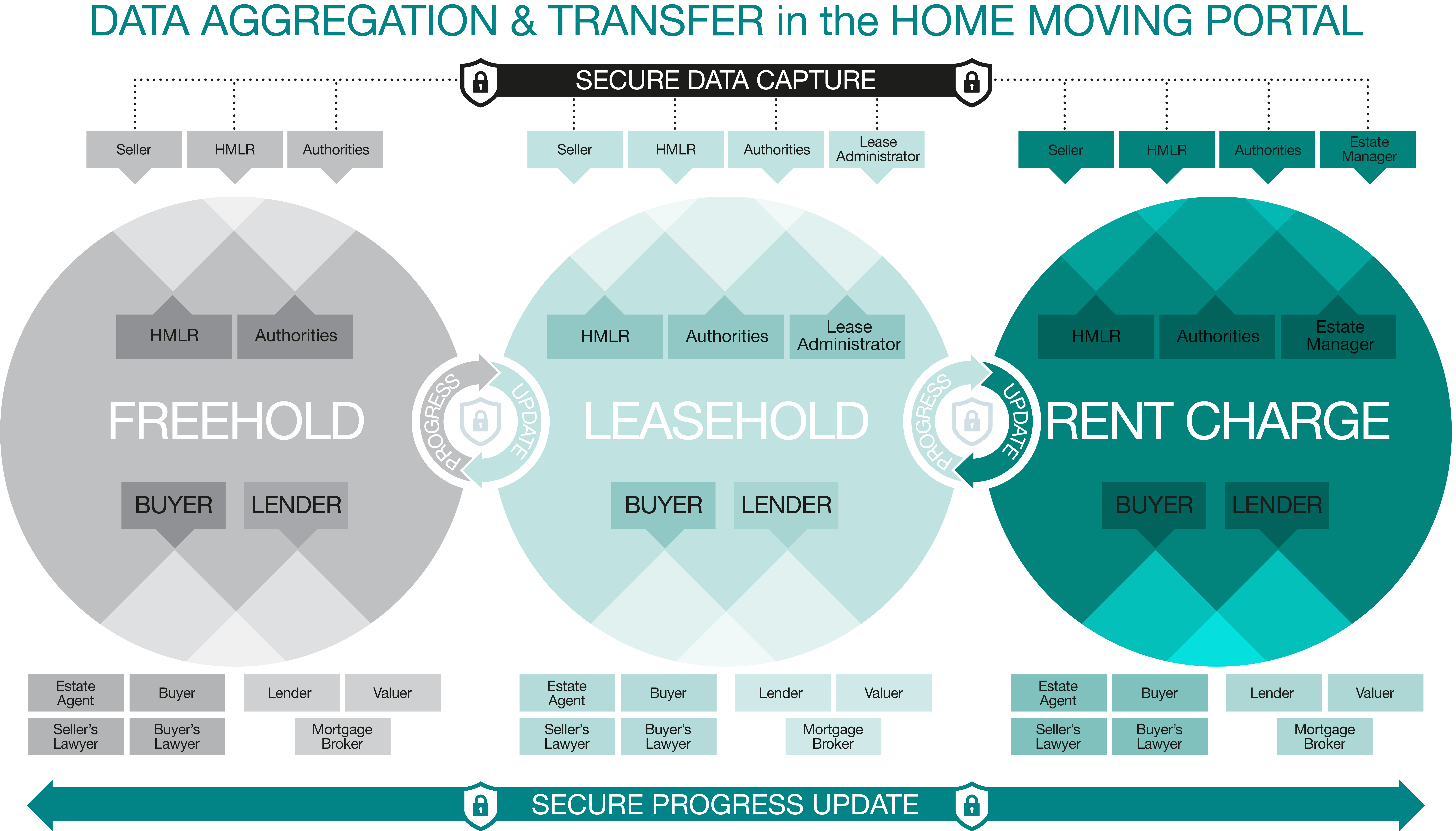
Conveyancing Association director Beth Rudolf comments: 'The greater use of UPRNs can enable better sharing of data to improve the consumer experience, both when transacting and occupying the property.' Figure 1 illustrates what Rudolf describes as 'the data exchanged between stakeholders in the home-moving process, based on the average chain of three and including all three likely tenure types. Analogue sharing currently results in a 22-week process, but once you can access it digitally everything falls into place. By being able to identify data relating to the geospatial location of the property, the UPRN removes all of the issues with address matching.'

Enhanced security and safety
In a recent open letter to the Ministry of Housing, Communities & Local Government (MHCLG) and the GeoSpatial Commission, Letting Industry Council founder Theresa Wallace commented: 'Widespread adoption of UPRNs could revolutionise the property market. This is an exciting initiative that has industry support, and we now need the government to add its own.'
By combining the UPRN with personal identification information, as the government now recommends, we can validate that participants in property transactions are who they say they are, to help prevent fraud, as well as supporting appropriate governance and access rights to protect data and privacy.
Having spent ten years in various areas of surveying, Rupert Parker MRICS observed that building information is scattered among stakeholders and lost as ownership and contracts change. He saw the opportunity to create Building Passport, a company providing a platform for stakeholders to collaborate in collecting data on a building-by-building basis. This eliminates the hassle of sending documents by email or file sharing sites, and also allows owners to supply information such as floor plans and riser locations to the emergency services to enhance security and expedite incident responses.
The platform makes use of the UPRN as a trusted identification method, and enables a historical record of building information to be stored regardless of changes in ownership. This aligns with the principle of a golden thread of building information proposed by Dame Judith Hackitt in her review of fire safety and the Building Regulations, as taken up in the Building Safety and Fire Safety Bills.
Property logbooks
The UPRN's ability to record the relationship between, say, an apartment block and the individual flats it contains, and identify whether these are freehold, leasehold or let on a particular tenure type, is critical to the concept of the property logbook and other digital data sets such as the Building Passport. This will not only allow data sets to be correctly linked but support appropriate governance and privacy controls when sharing and making data available to the various stakeholders of residential blocks.
The Residential Logbook Association (RLBA) was established in 2020 as an informal group of property logbook companies. It is working under the guidance of the MHCLG to create a consistent, regulated basis for logbooks to be used in conveyancing, rentals, retrofitting and other processes.
RLBA membership and marketing officer Tim Main states: 'The UPRN allows us to identify property and associated interests, linked by leases, [which] means that we can set up a system that will allow certain information to pass between [such] interests. We see this being particularly valuable for buying and selling, ground rent data, rental information, fire safety and cladding issues, new home data, retrofits, planning, and managing social housing.'
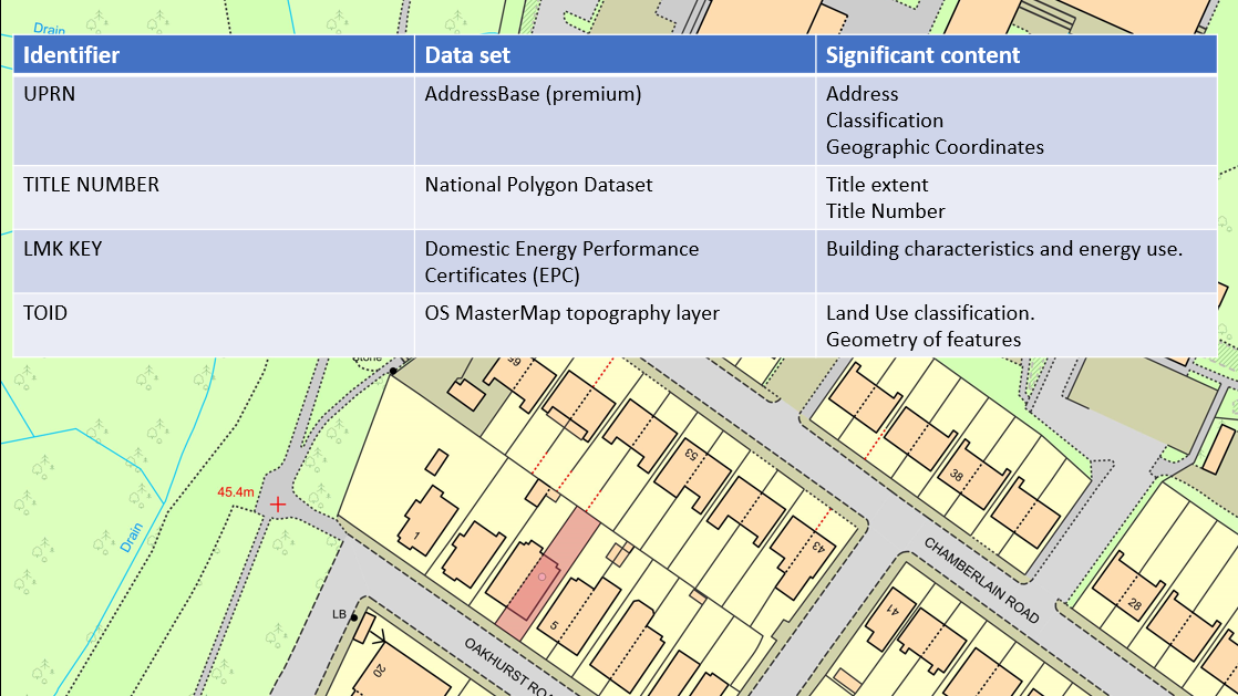
Information is increasingly being aggregated and presented in visualisations, enabling patterns of property attributes to be seen at neighbourhood, district, town, city, regional and national levels, as well as providing actual views of the property and its surroundings. Figure 2 shows the UPRN being used with other identifiers to collate title information from HM Land Registry, the EPC register, and the topographic identifier (TOID). This in turn locates the property on OS' MasterMap, creating the kernel of a property logbook.
OS product manager Louise Weale notes: 'We hope this helps to enable more innovation across the sector, laying the foundations for new technologies such as machine learning to offer insights previously impossible in the world of unstructured and siloed data. Much work has been done recently to make OS geospatial identifiers more widely accessible, with UPRNs and other linked identifiers available to all under the Open Government Licence.'

Accessing UPRNs
The maintenance of UPRNs and USRNs involves working with a large number of organisations. While there will on occasion be issues with data, the coverage and accuracy will improve the more that UPRNs are used by a wide range of stakeholders who feed back any issues they encounter.
As the housing sector helps to encourage adoption of UPRNs, we will see exponential increases in productivity and value in property transactions and building works, as well as gaining insights only made possible by connecting digital data sets in this way.
If the industry collaborates with the public sector, we can get a UPRN added to every form, database and property, and we will all then benefit as businesses and consumers. Residential property is too important to be left behind as other sectors take advantage of data and technology. Our profession can play a key role in collecting, managing and processing this data as well as ensuring its quality, provenance, and efficacy.
Useful resources
GeoPlace offers useful information on both UPRNs and USRNs. Meanwhile, OS provides a range of data sets free of charge under the Public Sector Geospatial Agreement. Consumers are also able to look up their own UPRN via the FindMyAddress site.
