The English Premier League kicks off its 2021/22 season in August with Manchester City reigning supreme as defending champions. But little does that team of footballing superstars know that when they run out on to the pitch, they are playing beside a 19th century colliery and a Second World War bomb site.
The site of the City of Manchester Stadium (CoMS), also known as the Etihad Stadium, faced heavy bombing in the 1939-1945 war with a distinct possibility some unexploded devices remained buried beneath the rubble. Aside from unexploded weaponry, the developers – architect Arup, and builder, John Laing – were faced with multiple contamination considerations on the proposed brownfield land that was earmarked for the stadium’s home when construction began in 1999.
These historic perils are revealed in analysis by Landmark Information, which shows a timeline of the site from the mid-1880s right through to 2080, when future floods are predicted.
Using data gleaned from Landmark Information, the British Geological Survey, and the Land Registry, Mike Holden, MD of Landmark Valuation Services, and Alex Wrottesley, MD of Landmark Geodata, can take any site and give a comprehensive background of it.
Deep diving through Landmark Data, Wrottesley and Holden took Modus on a 200-year journey of the City of Manchester Stadium and its environs, from the 1840s to the 2050s.
1848 - early data
The earliest data on the CoMS site is from 1848 and exposes some legacy land uses that impacted the modern-day development of the stadium.
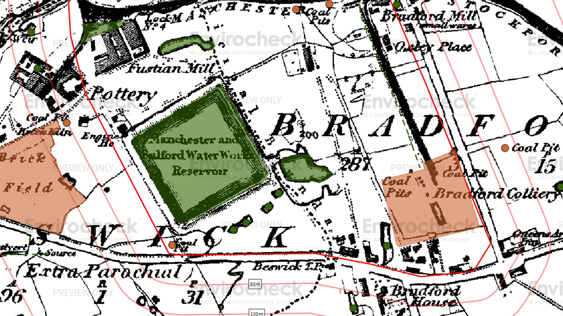
Using ‘data layers’, Wrottesley highlights potential ‘infilled land’ spots that were previously water. “When I go back to the old map, there is a green area here and if I click on it, it says ‘unknown filled ground pond marsh rivets and dock’. As I start to uncover the historical map, you’ll see it maps directly onto the Manchester and Salford Waterworks reservoir.
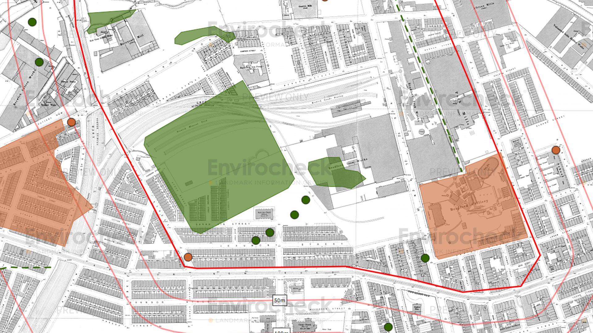
“Down in the bottom right, you’ve got the Bradford Colliery and if I go to another layer, and turn off 1848, this is 1891, where you get a detailed view that the colliery site has been infilled.”
To the north is the former area of industrial works, including iron works, mineral yards and mills.
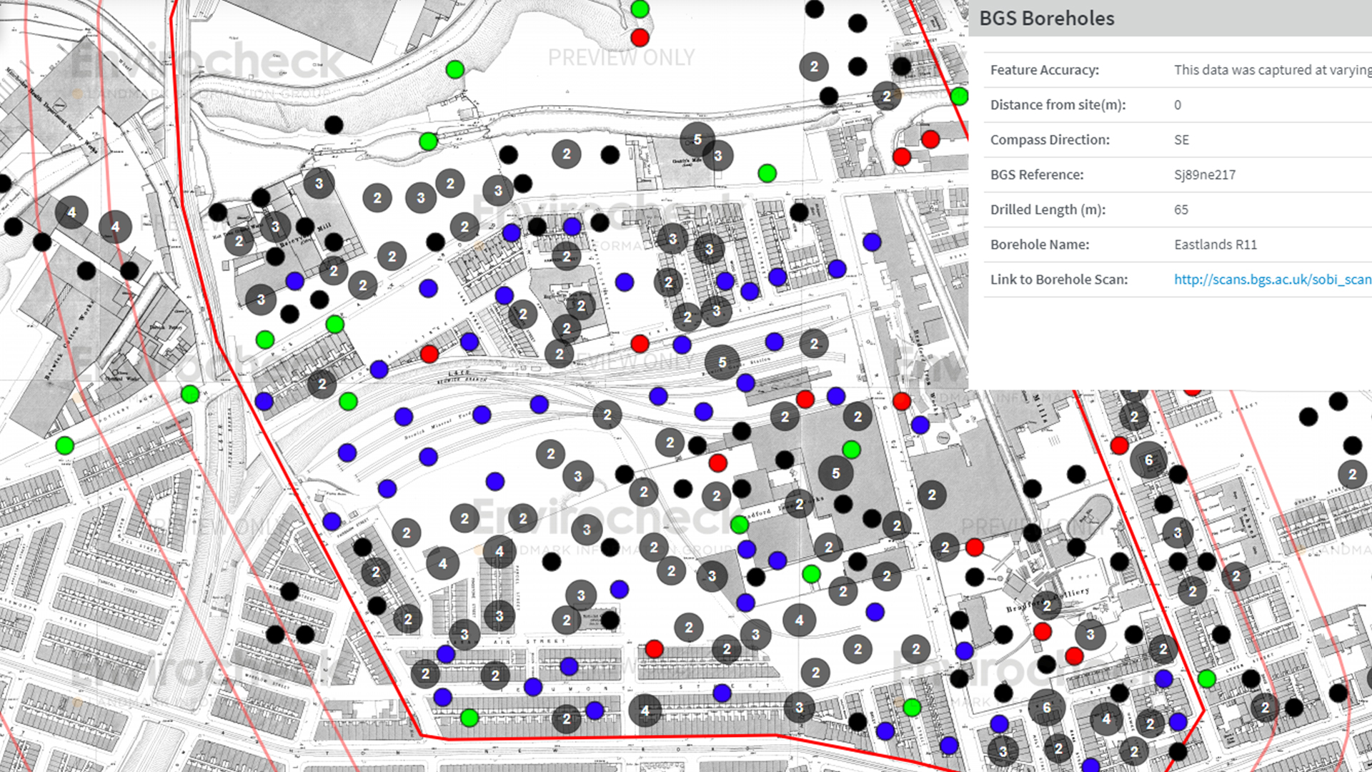
Image 1 - Data of infilled land from 1848. Image 2 - Data of infilled land from 1890. Image 3 - Data of Boreholes from 1890.
Mid-20th century
Wrottesley and Holden continue to add more layers of data to expose what happened to the site during the Second World War.
The Blitz (September 1940 to May 1941) saw 41,000 tonnes of bombs dropped across Great Britain with many falling over England’s northwest region. In December 1940, Manchester suffered its own personal Blitz and witnessed 578 tonnes of high explosive dropped on the city and surrounding areas in a weeks-long sustained raid.
It was described as ‘likely’ that building teams would encounter an unexploded bomb at the site for the yet-to-be-built CoMS. Landmark reports state: “A machine gun post was located near Philips Park Road - potentially on-site, while there were 16 Second World War ‘Luftwaffe Designated Bombing Targets’ identified in the area, the closest being Philips Park Gasworks and Bradford Ironworks.”
The next step, for a client, would be to run a more detailed unexploded ordnance (UXO) assessment of site risks.
A review of the available historical mapping data showed the site is on or within 25 metres of ‘Potential Tanks’ seen on a 1958 edition map, and usually associated with oil/fuel storage at past garages, depots or similar industrial land uses.
In December 1940, Manchester suffered three major bombing raids, which saw 578 tonnes of high explosive dropped on the city.
1990 to 2000s
In 1999, then prime minister Tony Blair laid the foundation stone for the CoMS in an unused brownfield site to the east of Manchester. Few would have predicted the stadium was to become a catalyst for revival for one of the UK’s quickest growing areas, with some of the fastest rising residential prices.
The stadium hosted the 2002 Commonwealth Games and in the surrounding areas the Manchester Regional Arena, a velodrome and national indoor BMX centre have all been built.
Given the scale of development, millions of pounds have been spent on infrastructure that includes completing the M60 as a full ring road and adding tram links for sports fans to get to and from the stadium.
This in turn makes it easier to live there and commute to Manchester for work with residential development around the stadium increasing in intensity. In 2014, it was announced that 6,000 new homes would be built, with an investment of £1bn over the following decade. Using key Landmark valuation data, surveyors can assess the impact the stadium has had on house prices in its vicinity:
- Between 1995 and 2021, house prices in the three postcodes closest to the stadium have increased by 473% (£24,941 to £143,024)
- The national average house price increase in England for that period is 404% and in the north-west of England the average is 317%
- In the seven years before the stadium opened, only 7% of house purchases in the area were new builds. In the 15 years after the opening, 31% of sales were new builds.
This shows the increase in investment in the area that has come from regeneration of the site,” says Holden. “Before the stadium, it was a mess: would you want to live next door to that? Probably not. Would a developer want to build lots of houses there? Probably not.
“Now, when you have a buzz around an area, you have businesses and transport links opening up, it’s a desirable place for developers to build houses. You can see the number of new builds there has rocketed.”
Current mapping of infilled land round the Etihad stadium.
2020 and beyond
The Landmark climate change report merges Landmark data with the Met Office’s climate change predictions, modelled on different carbon output scenarios.
And the predictions aren’t rosy: Landmark and Met Office data shows that potential for an increase in extreme precipitation create a very wet outlook for the area around CoMS by 2050.
On one map, Holden points to the Repeat Concentration Pathway (RCP) showing what is predicted to happen in 30 years. “These different shaded areas tell us the increased likelihood of flooding. The yellow areas are the most likely and we can see in the area around CoMS the likelihood of extreme precipitation, and therefore flooding, doubles by 2050” he says.
Holden adds that “Manchester is likely to experience more extremes in seasonal weather, with wetter winters and dryer summers becoming [the norm]. This in turn increases the likelihood of both flooding and subsidence in the area.”
One side effect of building on large pieces of land is that there is a lot of concrete because of carparks (for the stadium and other amenities) where there hadn’t been 20 years ago. This means there’s nowhere for the rain to go.
“There will be changing flood events because of climate change, and result of the developments in the area,” says Wrottesley.
It may be far off in the future, but all the knowledge gathered from the data will help generations to come plan for any necessary work, and repairs.
Between 1995 and 2021, house prices in the three postcodes closest to the stadium have increased by 473% (£24,941 to £143,024).

Landmark Information Group
Giving property and land professionals confidence through data Explore the data


