The pandemic has raised many issues about the evolution of cities. Among the models most often promoted as a response, the 15-minute city appears to have become an essential part of urban and political thinking.
The OECD has identified the 15-minute city as a model for building more inclusive, resilient, greener and smarter cities. Likewise, the UN Human Settlements Programme (UN-Habitat) has also drawn attention to this model and contributed to its greater global recognition.
What is the 15-minute city?
The concept of the 15-minute city was originally developed in 2016 by Carlos Moreno, a professor at the Panthéon Sorbonne University in Paris, France.
This model proposes polycentric, multifunctional, and compact urban development that would respond to the ecological, economic and social challenges that cities are facing today.
The theoretical objective of the model is to ensure that every inhabitant's needs are met within less than 15 minutes' travel by foot or bicycle, or more generally by non-motorised transport or public transportation.
These needs are classified into six social functions: to live, to work, to supply, to care, to learn and to enjoy. This model supports the design of multifunctional areas; that is, where the six different functions coexist. To do so, the 15-minute city must achieve three objectives: well-being, sociability and inclusivity.
Several major European cities have already embraced the model as part of their planning strategies. It is part of Paris mayor Anne Hidalgo's mandate for the city, and Milan's mayor Giuseppe Sala has made it a main objective of his urban policy. Cities in the USA, New Zealand and China have also shown interest in the model.
More specifically, the concept of the productive 15-minute city proposes to build on Moreno's. The idea of the productive city refers in particular to the location of employment, economic activities and companies, and the way in which such functions can be rethought to create more diversity and less monofunctional areas.
The two concepts encourage the design of multifunctional territories in the context of urban transformation in large industrial areas, combining economic activities, housing and various urban amenities.
Town focuses on tramway to overcome ruptures
In the Lyon metropolitan area in east-central France, the city of Saint-Fons is part of what is known as the Chemical Valley, a vast industrial zone with several Seveso-classified by the as facilities that deal with potentially hazardous chemicals.
Saint-Fons is the poorest municipality in the Lyon metropolis, where a large part of the population is working-class, there is an unemployment rate of 22%, and almost half of residents were living in social housing in 2019, according to national statistics.
Although it borders the city of Lyon and the seventh arrondissement – the second-largest economic centre in the metropolis, which is experiencing rapid urban growth and increased property building – the presence of the industrial zone, a waste disposal site, ring road, motorway and railway line create major territorial and social ruptures. The territory also lacks green and natural spaces.
In order to improve mobility and accessibility to this territory, the Metropolitan Council of Lyon and the public transport authority SYTRAL Mobilités are constructing the T10 tramway, which is due to be completed in 2026.
This will open up the territory and integrate green spaces along the new tramline and their rights of way.
The tramway aims to support the renewal of this disadvantaged area, offering a credible alternative to the use of individual cars to connect living and working areas and reinforce the appeal of Saint-Fons.
Several two-way streets will become one-way, and in very narrow areas the tram platform will be shared with local traffic. It is expected that this will make the tram a more attractive means of transport than cars, reducing air pollution.
The T10 project will also develop vegetation in the city and make urban soils more permeable to rain, improving the living environment as a means of adapting to climate change.
The construction of this tramline is part of important urban transformation for the metropolis, which is facing significant land pressure, particularly in the residential sector.
The T10 line will reconnect the centre of Saint-Fons to the south of the seventh arrondissement in 15 minutes, and to the urban dynamics of the metropolis.
Analysis assesses potential for 15-minute city
The model of the productive 15-minute city was used to better understand the territorial and urban dynamics of Saint-Fons and the six neighbouring municipalities, namely the seventh and eighth arrondissements of Lyon as well as Vénissieux, Feyzin, Irigny and Pierre-Bénite.
Information from 228 databases was used to characterise the variables that determined the six social functions described by Moreno.
The main databases used were those of national and local public organisation's such as the French National Institute for Statistics and Economic Studies, as well as local and national open-source data and Open Street Map.
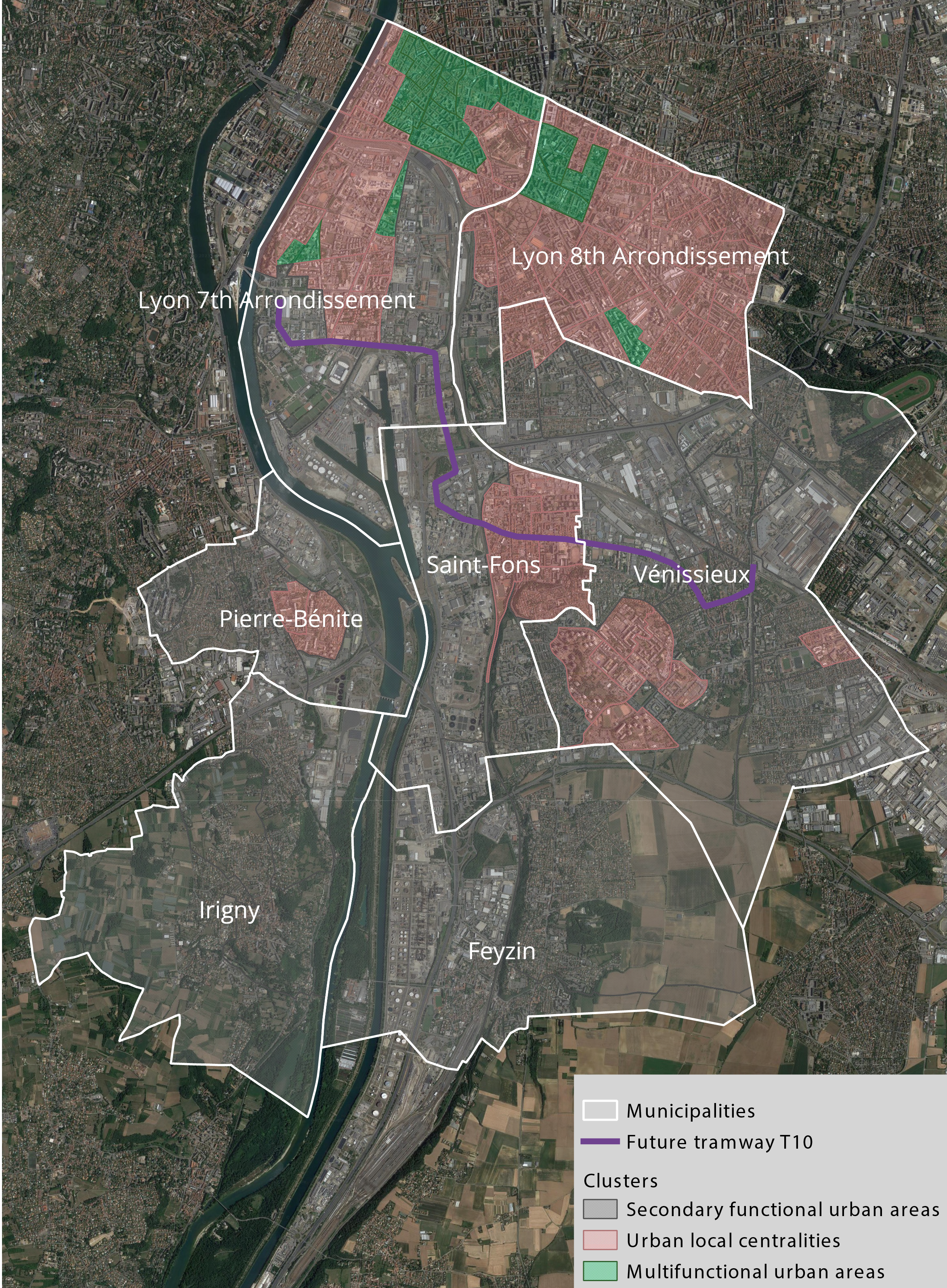
Applying the model allows the identification of three types of territory in the areas around the tramway, as illustrated in Figure 1.
- Cluster one, secondary functional urban areas, suffers from a lack of facilities for each of the six social functions.
- Cluster two, local urban centralities, regroups territories with specific and local functions found in the centre of a neighbourhood or a small city.
- Cluster three, multifunctional urban areas, should be sufficiently attractive and well equipped for a wide range of activities.
The analysis highlights the current hierarchical organisation of territories in this south-eastern area of the Lyon metropolis, with more multifunctionality found in the two arrondissements of Lyon. Fewer functions co-exist the further one travels away from this centre. Some social functions are present in the centres of Lyon's outlying municipalities, but a large part of the territory is industrial and monofunctional.

Figure 1: Urban and local space hierarchy for Saint-Fons and the surrounding municipalities along the future tramway T10, identifying activity clusters
The new T10 line will cross these areas and open up Saint-Fons by connecting it to the major public transport networks of the seventh arrondissement and the city of Vénissieux, allowing travel in less than 20 minutes while also linking areas with different functions.
This urban and local space hierarchy offers a planning tool to characterise such areas and evaluate their capacity to become part of a productive 15-minute city.
It is a simplified schema for urban planners, decision-makers, and real-estate developers to support urban transformation. The tram can be considered major infrastructure that could enable the development of a productive 15-minute city.
Acknowledgements
The authors would like to thank the French Ministry of Ecological Transition (MTE), the Research Programme on Transport Infrastructure, Territories, Ecosystems and Landscapes (ITTECOP), the French Agency for Ecological Transition (ADEME), SYTRAL Mobilités, and the data intelligence company Explore for their collaboration.
This article is based on work from the research project SEMEUR, Capacity of land transport infrastructures to meet the demand for Ecosystem Services in the Urban Environment – Methodological framework and experimental site in the territory of Saint-Fons, Grand Lyon, produced with the financial support of ADEME. The current work reflects only the authors' views, and the MTE is not liable for any use that can be made of the information it contains.
Carmen Cantuarias-Villessuzanne is an associate professor in economics at ESPI Paris
Contact Carmen: Email
Brice Barois is an associate professor in economics at ESPI Marseille
Contact Brice: Email
Myriam Zeller-Cohen is a trainee at ESPI Lyon
Contact Myriam: Email
Related competencies include: Infrastructure and services, Projects and people

