Rising global demand for crude oil has led to its increased marine oil transportation – and greater risk of oil spills.
Spills severely harm the marine ecosystem and nearby coastal areas, with significant environmental and economic consequences. Contaminating both freshwater and oceans, oil then affects the availability of clean water, causes desalination plants to shut, and damages mangroves, beaches and aquatic animals.
Minimising the damage caused by oil spills, though, can help to meet UN Sustainable Development Goal (SDG) 6 to improve water quality, and SDG 14 to protect marine life.
In the past, spills were detected by eye from synthetic aperture radar (SAR) imagery. But this is time-consuming because it involves visual inspection of large amounts of data.
Reliable, automated oil spill monitoring systems on the other hand, enable effective response and mitigation. They also help monitor ships releasing the toxic bilge water that accumulates in engine rooms, the illegal discharge of which is prohibited by the International Marine Organisation.
Machine learning improves the speed and efficiency of detecting oil spills. Deep learning (DL), which involves using layers of interconnected, artificial neural networks, is even more valuable in that, when set a problem, it can automatically learn which features to identify to solve it from the training data that has been input. It can also handle large amounts of data more efficiently and accurately than checking them by eye.
Model trained and automated to identify oil spills
With supervision from Dr Achraf Koulali, I developed an automated system for oil spill detection that involves a systematic approach combining advanced technologies, data preprocessing and machine learning. The project, which won the Council of European Geodetic Surveyors' 2023 Young Surveyors' Contest, involved first developing a DL model and then scripting for automation.
Development of the model began with collecting, preprocessing and labelling images of oil spills collected by the satellite Sentinel-1. This SAR imagery is crucial due to its ability to penetrate clouds.
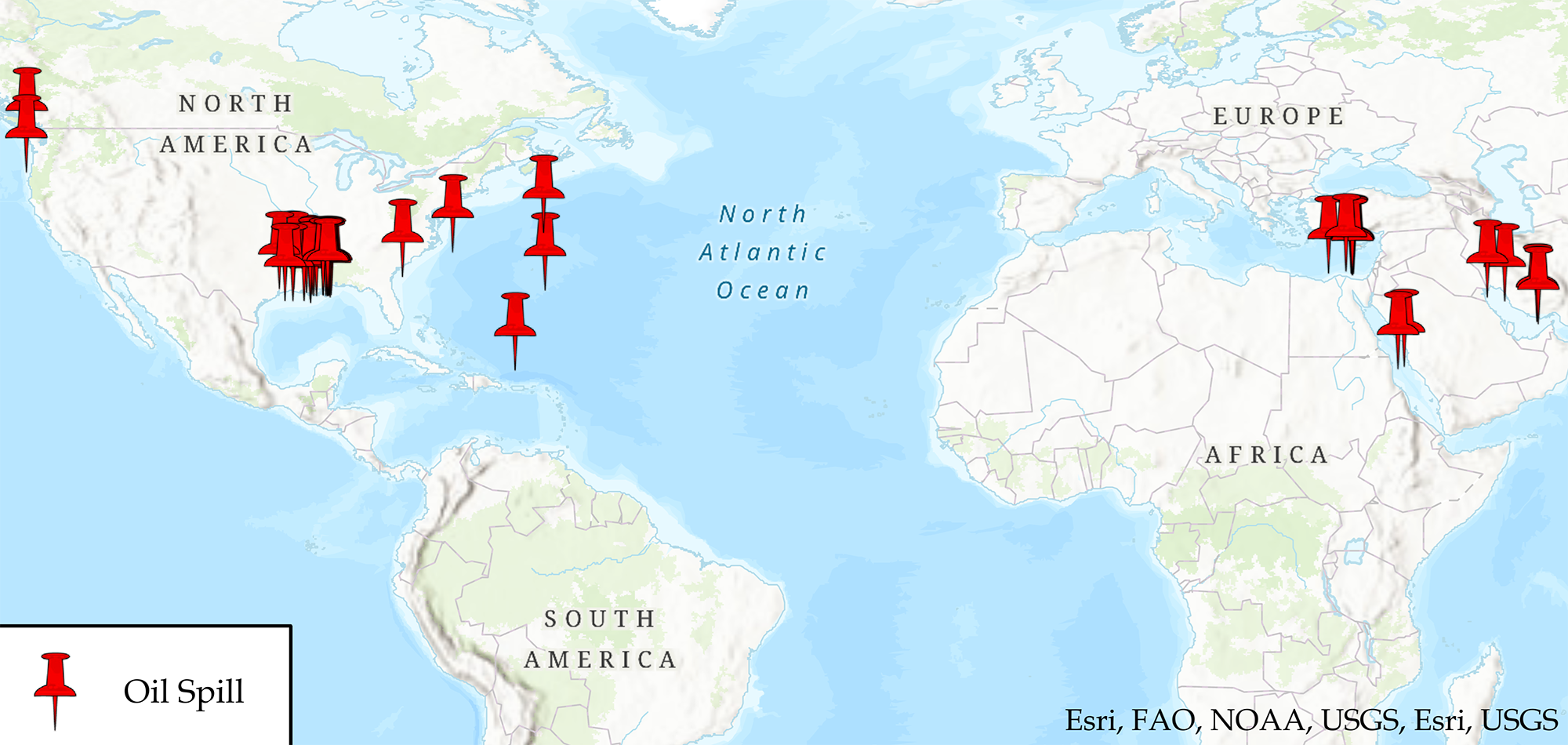
The dataset I used to train the model included various sizes of oil spill from different geographical areas, as shown in Figure 1. Some images, such as low-wind areas and biogenic slicks, closely resemble one another because they both dampen the return signal of the SAR satellite they alike dampen the signal returned to the SAR satellite, making them both appear dark in resultant images. They were included to enhance the model's ability to distinguish between actual oil spills and similar features.

Figure 1: Geographical distribution of oil spill scenes used in this study. Sources: Esri, UN Food and Agriculture Organization, US National Oceanic and Atmospheric Administration, US Geological Survey
The preprocessing involved operations such as extracting the VV polarisation band, updating satellite orbits, removing speckle noise, masking land areas, radiometric calibration, converting to decibel scale, downsampling and normalisation.
Once I had prepared the dataset, the DL models could be trained. This project used two DL models, U-Net and DeepLabV3+, which I chose for their ability to segment images; that is, to classify and categorise each pixel.
Training meant feeding the preprocessed images into the models, and evaluating how well these models predicted the presence of oil spills. I then measured the quantitative results using the intersection over union score, which assesses the overlap between predicted spills and those identified by eye.
When I had developed the model, I automated the entire process in programming language Python. The script I developed will download Sentinel-1 images, preprocess them, pass them through the trained DL models, post-process the predictions to reduce noise, and finally plot the output on an interactive map. The map allows the visualisation and interpretation of results.
The system aims to enable timely and accurate detection of oil spills as soon as Sentinel-1 passes over an area and takes new images. The combination of DL models and automation streamlines detection, making it more efficient and less reliant on inspection of large datasets by eye.

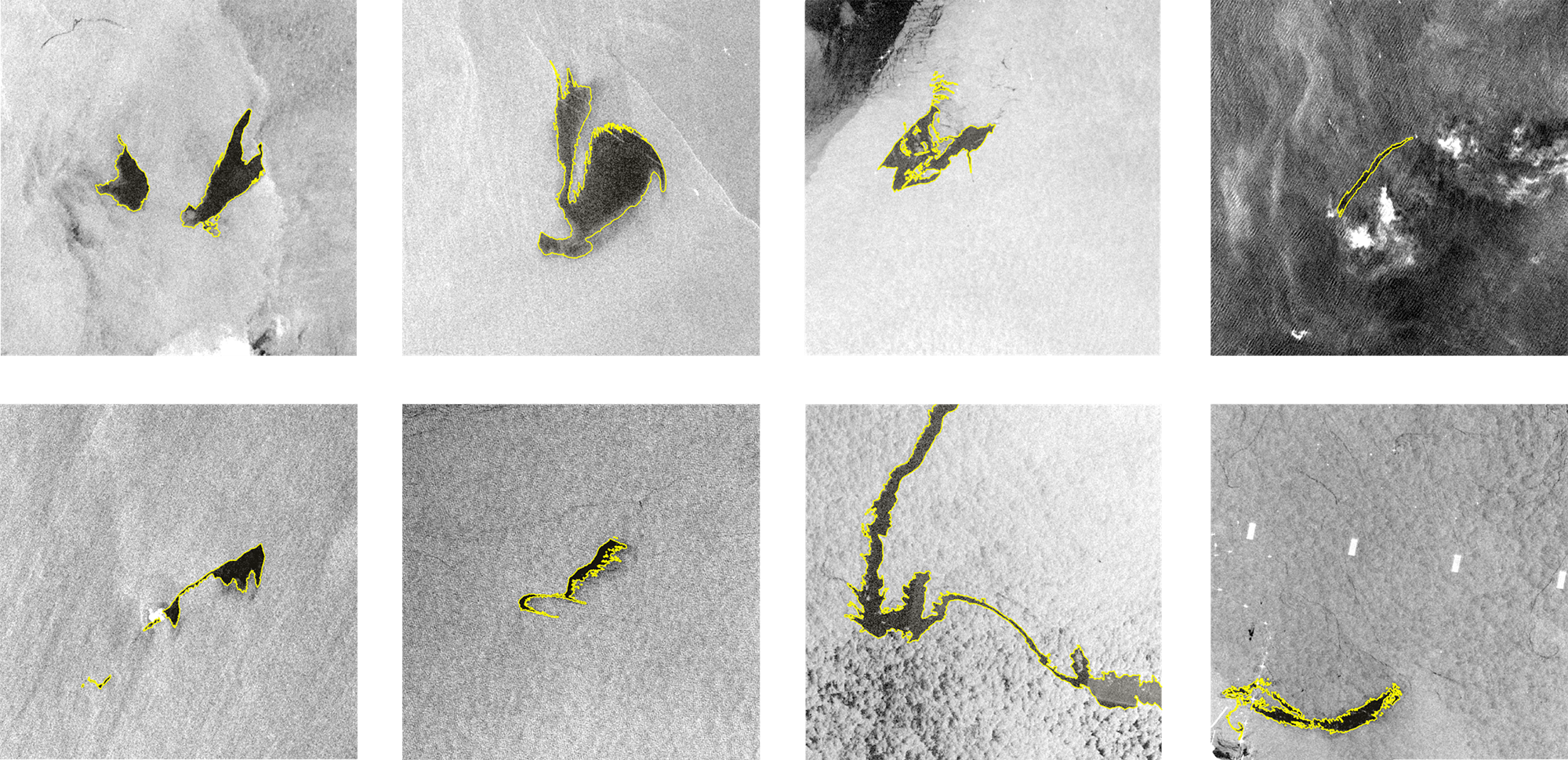
Figure 2: Examples of training images; oil spills are outlined in yellow. Image © Mohamed Al Hashmi
Deep learning improves detection speed and efficiency
One key advantage of DL over previous systems is its ability to learn relevant features automatically from the training data.
Unlike traditional methods, which often require manual identification of features, DL models can identify and extract important features themselves. This is particularly beneficial in complex tasks such as oil spill detection, where the visual characteristics of spills can vary widely.
DL models excel at handling large amounts of data efficiently. They can process vast datasets quickly and accurately, making them well suited to analyse satellite imagery as this often involves massive amounts of information. This efficiency is crucial for timely oil spill detection and response. What might have taken a remote sensing expert about 45 minutes to detect by eye can now be done in a few seconds.
Moreover, DL models – especially convolutional neural networks (CNNs) such as those used in this project – are adept at image processing. They can identify intricate patterns and spatial relationships in images, allowing us to define the precise boundaries of oil spills.
The project highlights how technological advances affect surveying practice. The model is particularly useful for surveyors involved in environmental monitoring, increasing the efficiency and accuracy in detecting not only oil spills, but also features such as water bodies, or built-up areas, and the ability to deal with environmental challenges more proactively.
Interactive maps generated by Python provide a clear and accessible way to interpret and communicate the results of environmental monitoring to all involved in cleaning up the spill.
'Deep learning models can process vast datasets quickly and accurately, making them well suited to analyse satellite imagery'
Project offers potential for wider application
The automated oil spill detection project can be adapted for other types of environmental monitoring, including the detection of hazards such as deforestation, wildfires or pollution.
The methodology is also applicable to natural disaster response, enabling automated identification and mapping of areas affected by events such as floods or earthquakes. The system could be extended to infrastructure monitoring as well, where critical structures such as pipelines and roads may be monitored for damage or anomalies.
In agriculture, the model could be trained to detect diseases and pests, and assess overall crop health. Urban planning and development may meanwhile benefit from the system's ability to monitor changes in land use, identify illegal construction and help manage urban growth.
Furthermore, the project is adaptable for wildlife conservation, involving the detection and monitoring of animal habitats, counting populations and identifying potential threats using aerial or satellite imagery.
In each case, the key is adapting the project by selecting relevant data, adjusting preprocessing stages, and training the DL model to recognise specific patterns associated with the target application.
RICS and CLGE
RICS is once again working with colleagues at CLGE on the 2024 CLGE Young Surveyors' Contest and would encourage all geospatial students in the UK and Ireland to enter.
We are proud that Mohamed, a graduate from Newcastle University, is the first UK winner of this pan-European competition. It would be wonderful to see another winner from these islands. There are great cash prizes plus an expenses-paid visit to INTERGEO in October 2024 in Stuttgart for the three winners in each category.

