Over the past year, data management firm EcoSpatial Solutions has been working with the Canal & River Trust to gather baseline data and measure improvements in biodiversity net gain (BNG) accurately in England and Wales.
The trust has committed to survey the condition of existing habitat on its waterways and develop a management plan for optimum nature conservation value, such as species richness, biodiversity and abundance, while considering the constraints of the other waterway uses and activities. With the new BNG framework in mind, the trust has an opportunity to discuss enhancements on its land with partners that want to make habitat improvements off site.
It was therefore decided to build a GIS tool that would map the whole network using geospatial information to establish a baseline and then continuously track biodiversity.
In the long term, this GIS tool must enable the trust to identify BNG and other ecological-funded projects that receive funding from developers and others to offset habitat destruction. It also has to store information about landownership related to these projects and allow the automatic submission of changes to the baseline that occur when any type of work is carried out such as repair of a lock.
To this end, the trust worked with EcoSpatial, which has used the latest GIS technology from software developer Esri to process, store and analyse data about the baseline, as well as visualising this in a clear and accessible way for both technical and non-technical professionals.
In addition, the trust wanted an internal survey system that would also allow it to maintain and evaluate land-use changes as they were made without the need to re-survey the entire network.
Canal & River Trust responsible for habitat management
Founded in 2012, the charity Canal & River Trust looks after a 2,000-mile (3,200km) network of canals and navigable rivers in England and Wales. These waterways connect many of the UK's urban and rural areas, providing essential spaces for wildlife and people.
The trust plays a key role in protecting existing habitats and creating new ones, safeguarding wildlife during canal repairs and managing water quality. It is responsible for 68 sites of special scientific interest and around 3,000 county wildlife sites, and manages more than 700 miles (1,125km) of canals that have been awarded a Green Flag.
Platform records baselines and tracks changes
Network-wide ecological survey data, which included UKHABs Habitats ID, the habitat condition predicted by a statistical analysis, and associated photographs, had previously been collected by environmental consultancy FPCR Environment and Design.
Using the ArcGIS Pro desktop GIS, the EcoSpatial team processed data collected by FPCR, which consisted of 115,000 survey points, 35,000 survey lines and 160,000 polygons in line with the biodiversity metric 4.0 data standard, to provide the overall baseline BNG calculations.
The opportunities this offers to support decision-making are considerable. Analysis of new and existing survey data can inform decisions about vegetation clearance and landscape design, while incorporating habitat data means BNG is integrated into the design process and changes can be made to optimise outputs early on, when it is cheaper to do so.
The interactive platform created by EcoSpatial for the trust allows users to query the data to find suitable BNG units based on size, location and landownership type. Baseline data can be further edited and updated as desktop and field users continue to survey.
Auto-completion of the smart survey forms reduces the time that surveyors spend entering responses and eliminates human error in assigning condition scores.
This helps non-technical colleagues to engage with data and clarifies concepts such as BNG. Such accessibility not only enables communication between designers, GIS technicians and ecologists but also with project managers and stakeholders.
Users can query habitat data to inform decisions
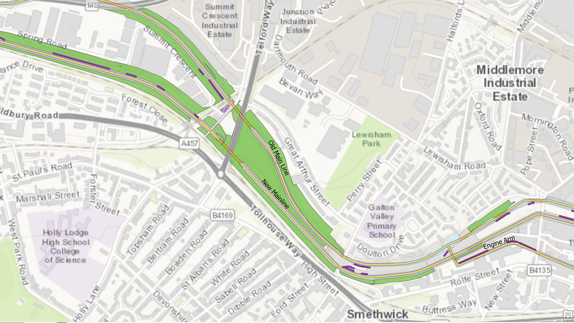
The domain structure and use of models in the GIS platform made processing of this magnitude both possible and repeatable. EcoSpatial then generated dashboard visualisations in Experience Builder, Esri's development platform, enabling the trust to show stakeholders the habitat, hedgerow and watercourse baselines, and query or export the data to inform future decisions.
For example, a user looking for a site for habitat enhancement can use the habitat dashboard to see biodiversity unit totals across multiple scales, including the total baseline across entire trust network, total baseline scores across broad habitat types (e.g. woodlands, grasslands, etc.) and scores for individual polygons.
They can filter data based on broad habitat type, local planning authority or habitat condition to identify relevant habitat parcels for off-site credits based on geographical location, or explore those with potential for restoration.
In addition, by overlaying other designations such as local nature reserves, users can add further context to the trust's data to identify and engage with local stakeholders on future nature recovery projects.
To support surveyors and ecologists working in the field, EcoSpatial also developed a new survey system to validate the habitat ID and assess their condition, which gives the option of redrawing polygon boundaries or editing an existing habitat parcel depending on the original data.
The system then automatically populates forms with contextual information such as a surveyor's name, date and time, local planning authority and trust operational area.
Once a surveyor has identified the habitat type, the relevant condition assessment sheet will appear on screen with a selection of questions. When complete, this survey automatically totals the score of the assessment, assigns a separate score for the condition and also calculates a biodiversity unit score for that habitat parcel.
Out-of-the-box field surveying platforms that use the programming language Arcade as Esri's do can be customised to the trust's needs and requirements, enabling further expansion and development.

Figure 1: An example of baseline habitat parcels in green, hedgerow lines in purple, and watercourses in yellow. © Canal & River Trust
BNG requires accurate, accessible information
Using GIS for BNG operations ensures the Canal & River Trust complies with the biodiversity metric 4.0 by generating consistent and well-managed data. As a single source of truth for all biodiversity baselines, this reduces uncertainty and allows different departments of the trust to export data that meets developers' environmental reporting needs.
The project also demonstrates the need for accurate, consistent GIS data. Biodiversity metric 4.0 does contain a basic GIS standard but there are no requirements in the BNG guidance for raw GIS data to be submitted as part of the development planning process. Neither does the guidance offer direction on how the quality of data used in map figures can be determined.
A range of professionals such as designers, developers, ecologists, data managers, and planners are now responsible for improving the quality of natural habitats. Those who are out in the field collecting data have a major effect on data quality.
While existing dashboards and applications can provide useful insights, if the data informing those insights is poorly managed then the resultant calculations and recommendations cannot be trusted. This project aims to tackle those small errors or misinterpretations that can result in poor decision making.
It is important for surveyors to understand how their systems for collecting and managing data affect its integrity and accuracy, which requires the standardisation of collection and management methods.
To develop effective nature recovery strategies that do not create more work for those who implement them therefore demands significant investment in devising processes for automated analysis and managing data.
Using advanced GIS technology in BNG operations can provide impressive dashboards and reports for stakeholders – but these reports will be worthless if data is substandard. With properly maintained data structuring, however, the Canal & River Trust can now manage land to support ecological recovery and properly account for its natural capital.
'The trust can now export data that meets developers' environmental reporting needs'
Dr Katie Dawson is a founder and technical director of EcoSpatial Solutions
Neil Neigenfind is a GIS specialist at the Canal & River Trust
Related competencies include: GIS (geographical information systems), Land use and diversification, Management of the natural environment and landscape, Surveying and mapping

