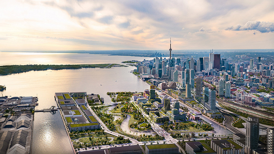
Future of the Port Lands. Image courtesy of Waterfront Toronto
In 1969, a funeral procession wound its way through Toronto until it reached the banks of the Don River. A group of black-clad mourners marched somberly as they escorted a casket while others clutched flower bouquets. Some wept behind veils.
The deceased? The river itself. Cause of death? Pollution.
This mock funeral more than 50 years ago was one of the first citizen efforts to save the beleaguered Don River, which winds 24 miles through greater Toronto and drains a watershed that is home to 1.4m people. But, to paraphrase Mark Twain, reports of the river’s demise have been greatly exaggerated.
Today, the mouth of the Don River is at the centre of a CA$1.25bn infrastructure project to re-naturalise the river, prevent future flooding and build a new neighbourhood. The scheme, known as the Toronto Port Lands Flood Protection Project, is one of the most ambitious waterfront redevelopment efforts underway worldwide. With its combination of green infrastructure and new land for mixed-use, mixed-income property development, Canada’s biggest city is pushing the envelope for urban resilience.

Photo of the mock funeral from 1969. Image from Pollution Probe / Tom Davey
“The waterfront has not been considered as part of the city for quite some time” says Waterfront Toronto’s chief project officer David Kusturin. “We were created to reconnect the city to the waterfront.”
That mission has guided Waterfront Toronto, a tripartite planning organisation with representation from the city, provincial, and national governments, since its founding in 2001. The organisation has had a string of successes along Toronto’s central waterfront over its two decades of existence. Some are seasonal, like Sugar Beach, a two-acre urban beach that opened in 2010, whose pink umbrellas have transformed the pocket park into an iconic public space. Others are year-round draws, like George Brown College’s Waterfront Campus, which brings 3,500 students and 500 faculty staff to a 41,000m2 building that houses medical education. These amenities, meanwhile, have drawn private developer interest to build 6,000 residential units in what’s now known as East Bayfront.
Keating Channel
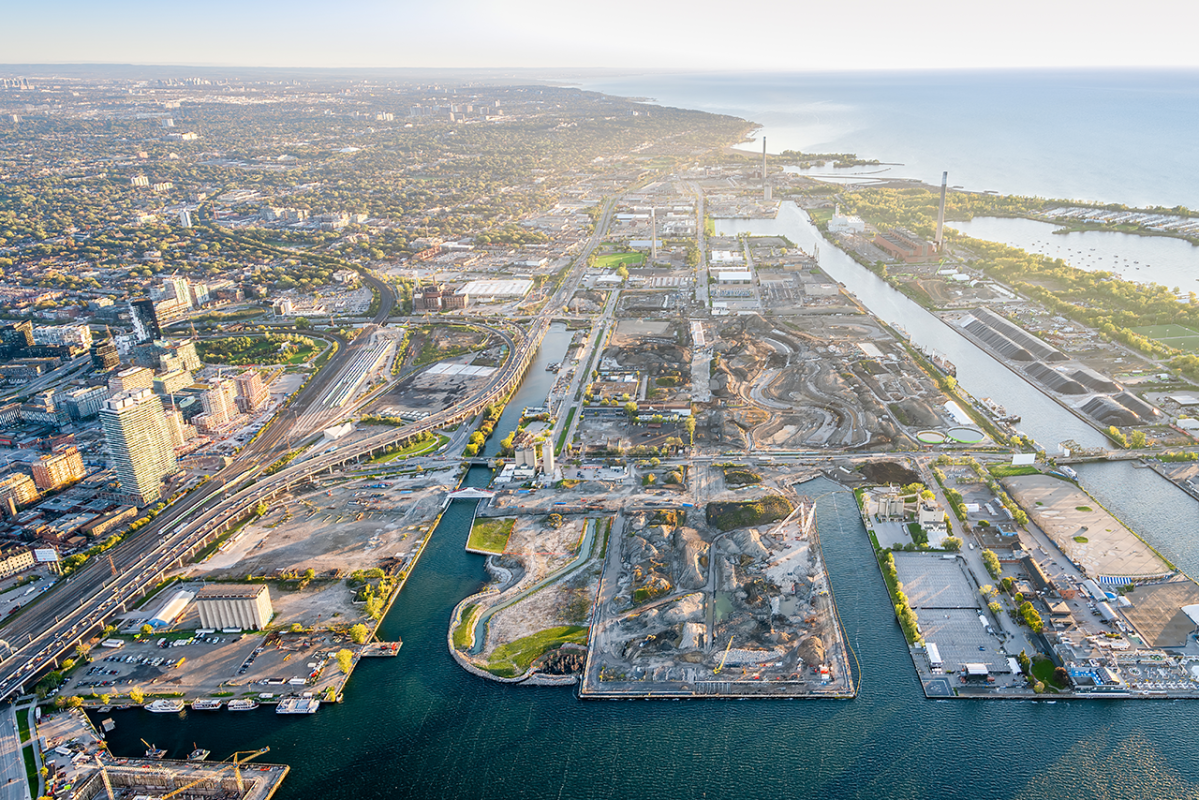
Waterfront Toronto hopes to build on this momentum as it turns its attention to the next neglected parcel of industrial land on the city’s waterfront, but one with a much more complicated legacy. Turn your gaze farther east from the promenade along Lake Ontario that flanks the fresh construction in East Bayfront and you’ll be looking up Keating Channel. This concrete funnel disappears into a right-angle turn, an unnatural bend that comes courtesy of 1950s and ‘60s engineering works to channelise the lower Don and build a highway inland along the river. These public works precipitated the 1969 mock funeral by environmental activists.
But it would take another 20 years from that agitprop stunt to see any progress. In 1989, the city council created the Task Force to Bring Back the Don, which set the goal that “the Don River and its related recreation and wildlife areas be made fully useable, accessible and safe for the people of Toronto no later than the year 2001.”
However, by 2001 the city had only gotten as far as chartering Waterfront Toronto. One of its earliest tasks was to protect the Don River from flooding, a frequent occurrence. The heavily hardscaped watershed sends inordinate amounts of stormwater cascading through the river system where it smashes up against the unnatural right hand turn into Lake Ontario. Authorities must continually dredge the otherwise rarely used Keating Channel, meanwhile, to prevent even worse flooding should the channel become too shallow. Ice jams during Ontario’s frigid winters don’t help matters either.
The flood risk on the Don is measured against one historic benchmark: Hurricane Hazel. In October 1954, a Category 4 hurricane struck southern Ontario. The torrential downpour killed 81 people and caused CA$100m (CA$1bn today) in damage. That catastrophic event precipitated the creation of Ontario’s pioneering system of conservation authorities, or local watershed management agencies, and led to stringent building regulations in flood plains. Those rules left much of the land fallow around the mouth of the Don River, permitted for industrial use but unable to be upgraded into commercial, residential or parks.
"Toronto has demonstrated that it is possible to do what seems like an insurmountable feat” Laurian Farrell, Resilient Cities Network

Aerial shot of the Port Lands in development. Image from Waterfront Toronto
Floodproofing the banks of the Don River
Waterfront Toronto has slowly been chipping away at that challenge by floodproofing land along the Don’s banks, starting with the West Don Lands on the north side of Keating Channel and west side of the river. Through grading and landforming, the agency remediated 80 acres to accommodate a neighbourhood with 6,000 residents, an elementary school, two childcare centres, commercial spaces and 23 acres of parks and public space. That effort was completed in 2015 as part of the city’s preparations to host the Pan-American Games.
Another parcel is now in the crosshairs on the south side of Keating Channel with the most ambitious infrastructure piece yet: to restore the Don River’s natural flow. Doing so will require turning a peninsula into an island, as a chunk of the Port Lands is rechristened as Villiers Island. This 83-acre site is now the centre of engineering works on the scale of those a generation ago to channelise the river and build a highway, except this time their outcomes will be just the opposite. Instead of emptying into Lake Ontario from the straitjacket of Keating Channel, the Don River will meander into the lake at an outlet 500 metres south.
“It’s not easy to reverse past planning decisions,” says Laurian Farrell, North America director at Resilient Cities Network. “The foresight, vision and political will to get this work done is inspiring. Toronto has demonstrated that it is possible to do what seems like an insurmountable feat.”
As construction crews re-engineer a natural river system with ample marshland to absorb future storms, they are planning for Hurricane Hazel and then some. “We know the intensity of storms is increasing,” says Kusturin. “We’re planning around the regulatory storm plus another 50cm of water height.”
Rewilding success
Waterfront Toronto is also seeding the riverbed with dead trees to create a functioning ecosystem and attract aquatic life. Already, seeds buried in the peat are sprouting century-old bulrush – proof positive that rewilding works. When the river finally starts flowing, planners hope to see foxes, turtles, great blue herons and dragonflies joining human neighbours.
Those human neighbours will follow from a blueprint that Waterfront Toronto has fine-tuned in Bayfront East and the West Don Lands. First, the agency prepares heavy-duty infrastructure and a top-notch public realm. In the case of Villiers Island, that upfront investment includes a district energy plant, a deep shaft for geothermal energy and deep lake water cooling to handle the island’s energy needs. The new wastewater treatment plant uses UV light to kill bacteria and return water to Lake Ontario at 99% purity. These nuts and bolts are among the features that will make Villiers Island a so-called ‘climate positive’ neighbourhood. High-speed internet with lower prices locked in for tenants of the district’s affordable housing units is another infrastructure perk. The public realm, meanwhile, includes marquee parks, playgrounds and water access for canoeing and kayaking.
Attracting private sector investment
All those investments show the private sector that the public sector has a vested interest. “Developers are doubtful about government’s ability to deliver,” says Kusturin. “We get the infrastructure going so they can see that there is a financial commitment and capability.”
That commitment entices property developers to respond to the agency’s carefully-structured request for proposals (RFPs). This seeks to capitalise on private sector investment, while also delivering on a social mandate to provide affordable housing in a city facing a double squeeze for both rental and homeownership. “There’s no question they would rather be selling 60-storey condos,” says Kusturin. “But if they can’t make their returns, they’re not going to build.” Nearby, Waterfront Toronto’s Quayside site was a nearly two-year process to select Quayside Impact Limited Partnership, a joint venture between Canadian firms Dream Unlimited and Great Gulf Group.
Sometime next year, the river will finally run its proper course once again. Farther down the road, residents will live along its banks. And when the inevitable storm comes, they will watch without fear as the parks and marshy riverside absorb the water below while they stay dry in their homes above.

